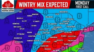
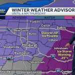
A messy winter system is set to move through south-central Pennsylvania on Tuesday, bringing a mix of snow, sleet and rain to the region.
Forecasters say the week will begin on a colder note before temperatures gradually rise later in the workweek. The unsettled pattern could bring multiple rounds of rain through Friday.
For commuters, school districts and businesses across cities like Harrisburg, York and Lancaster, Tuesday’s mix may create slick roads during the morning and evening drive.
Here’s what residents in south-central Pennsylvania should know about the shifting weather pattern and what it could mean for the days ahead.
Weekly Weather Outlook for South-Central Pennsylvania
Cold Start to the Workweek
Temperatures across south-central Pennsylvania began the week below seasonal averages.
Overnight lows dipped into the 20s and low 30s in many areas, setting the stage for frozen precipitation as the next system approaches.
Meteorologists say surface temperatures early Tuesday will be cold enough to support snow or sleet at the onset, particularly in higher elevations and northern portions of the region.
“The concern is that we start cold,” said a meteorologist with the National Weather Service office serving central Pennsylvania. “Even a light glaze can make untreated roads slippery.”
Tuesday’s Wintry Mix: Snow, Sleet and Rain
The primary weather event this week arrives Tuesday.
Forecast models indicate precipitation will move into south-central Pennsylvania during the morning hours, beginning as light snow or a rain-snow mix.
As temperatures gradually climb above freezing, the precipitation is expected to transition to plain rain by the afternoon in many locations.
However, that changeover may take longer in elevated areas, where cold air can linger near the surface.
“Timing is everything with systems like this,” said a private-sector meteorologist based in Pennsylvania. “If the warmer air arrives a bit later than expected, that’s when you can see more sleet or freezing rain.”
Even minor ice accumulation can create hazardous travel conditions, particularly on bridges and untreated roads.
Why This Weather Pattern Matters
Wintry mix events are often more disruptive than pure snowstorms.
Snow can be plowed and treated. Ice, even in small amounts, tends to cause more accidents and power outages.
In south-central Pennsylvania — where rolling terrain and rural roadways are common — brief periods of freezing rain can quickly create dangerous driving conditions.
Local emergency management officials typically monitor these transitional storms closely because impacts can vary town by town.
For school districts and employers, Tuesday morning’s conditions may factor into delay or closure decisions.
Moderating Temperatures Late Week
After Tuesday’s system exits, a gradual warming trend is expected.
Daytime highs are forecast to climb into the 40s and potentially low 50s by Thursday and Friday, depending on cloud cover and rainfall timing.
The milder air will limit additional frozen precipitation threats for the second half of the week.
Instead, the focus shifts to periods of rain.
“The overall pattern remains active,” the National Weather Service noted in a recent forecast discussion. “We’re not seeing a prolonged dry stretch just yet.”
Unsettled Pattern: Multiple Rain Chances
Weather models show several weak disturbances moving through the Mid-Atlantic later this week.
These systems could bring intermittent rain showers from Wednesday through Friday.
While widespread flooding is not currently forecast, saturated ground conditions combined with repeated rainfall could cause localized ponding in poor drainage areas.
Rivers and streams will also be monitored, especially if rainfall totals trend higher than expected.
Timeline of Events
-
Monday: Cold conditions across south-central Pennsylvania; dry but below average temperatures.
-
Tuesday Morning: Precipitation begins as snow or wintry mix.
-
Tuesday Afternoon: Transition to rain as temperatures rise above freezing.
-
Wednesday–Friday: Warmer conditions with periodic rain chances.
-
Late Week: Highs potentially reach upper 40s to low 50s.
Official Forecast Snapshot
| Event | Location | Date | Who Is Affected | Current Status | What Readers Should Know |
|---|---|---|---|---|---|
| Wintry Mix (Snow/Sleet/Rain) | South-Central Pennsylvania (Harrisburg, York, Lancaster region) | Tuesday | Commuters, schools, businesses | Active weather system expected | Slippery roads possible during morning; precipitation transitions to rain |
| Moderating Temperatures | South-Central Pennsylvania | Late Week (Wed–Fri) | Entire region | Gradual warming trend | Highs climb into 40s/50s; mainly rain expected |
| Multiple Rain Chances | South-Central Pennsylvania | Mid to Late Week | Drivers, local communities | Unsettled weather pattern | Periodic rain showers; monitor for localized ponding |
Public Reaction and Community Preparation
Ahead of Tuesday’s system, some residents took to social media to ask about road conditions and potential school delays.
Local highway crews have prepared by pre-treating major roadways where necessary.
Many drivers expressed concern about early morning commutes, particularly in rural areas where temperatures tend to stay colder longer.
“We’ve learned not to underestimate these mixed events,” said a York County resident. “It only takes a thin layer of ice to cause problems.”
What Happens Next?
Forecasters will continue to refine precipitation timing and temperature projections.
If surface temperatures trend colder than currently expected, the risk of freezing rain could increase.
Conversely, a quicker warm-up would limit ice concerns but increase rainfall totals.
Updated forecasts and advisories are expected as the system approaches.
Frequently Asked Questions
1. Will it snow in south-central Pennsylvania this week?
Yes. Snow is possible Tuesday morning before transitioning to rain.
2. Is freezing rain expected?
Freezing rain or sleet is possible early Tuesday if surface temperatures remain below freezing.
3. How much snow accumulation is forecast?
Current projections suggest light accumulation, mainly before the change to rain.
4. When will temperatures warm up?
Temperatures are expected to moderate by Wednesday and continue rising into Thursday and Friday.
5. Will schools close due to the weather?
School decisions depend on local conditions Tuesday morning. Minor ice could impact delays.
6. Is flooding a concern later this week?
At this time, widespread flooding is not forecast, but localized ponding during heavier rain is possible.
7. How long will the unsettled weather last?
Rain chances persist through the workweek, with drier conditions potentially returning next weekend.
What Residents Should Watch Next
The key factor to monitor is Tuesday morning’s temperature trend.
A few degrees can determine whether precipitation falls as snow, sleet, freezing rain or plain rain.
Residents across south-central Pennsylvania are encouraged to check updated local forecasts before commuting Tuesday and stay alert for potential advisories.
The warming trend later in the week may ease winter concerns — but the active weather pattern is not done yet.


Leave a Comment