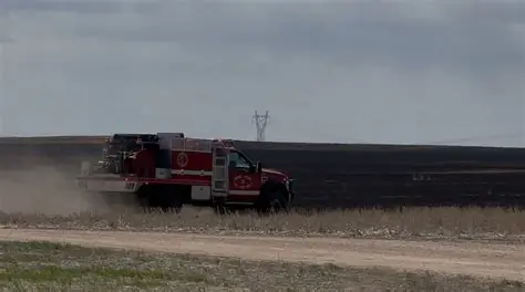
Fire conditions are turning volatile across parts of the central High Plains.
Forecasters say a mix of powerful winds and very dry air could create rapid wildfire growth across eastern Colorado, southeast Wyoming, and western Nebraska.
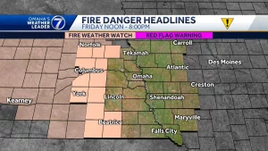
The National Weather Service has issued Fire Weather Watches for the Colorado Front Range, the I-25 corridor, and surrounding areas. Officials warn that any fire that starts could spread quickly.
The alert matters because these regions have already seen dry fuels and fluctuating winter weather patterns, making early-season fire behavior harder to predict.
Fire Weather Watch: Key Facts at a Glance
| Event | Fire Weather Watch Issued |
|---|---|
| Location | Eastern Colorado (Front Range & I-25 corridor), Southeast Wyoming, Western Nebraska |
| Date | February 2026 |
| Who Is Affected | Residents, ranchers, outdoor workers, and travelers in alert areas |
| Current Status | Elevated wildfire risk due to wind and low humidity |
| What Readers Should Know | Avoid open burning, secure trailer chains, follow local fire restrictions |
Why Fire Danger Is Rising Across the High Plains
The National Weather Service offices in Denver, Cheyenne, and North Platte are tracking a strong weather system moving through the region.
Forecast models show sustained winds between 25 and 40 mph, with gusts potentially exceeding 60 mph in some areas. At the same time, relative humidity levels could drop into the low teens.
That combination is critical.
“When you pair strong winds with very dry air, fires can spread at a dangerous rate,” the National Weather Service said in a briefing statement. “Conditions like these significantly increase the risk for rapid fire growth.”
Dry grasses and dormant vegetation from winter remain highly combustible. Even a small spark — from equipment, vehicles, or discarded cigarettes — could ignite a fast-moving grassfire.
Areas Under Fire Weather Watch
Colorado Front Range and I-25 Corridor
Communities from Fort Collins through Denver and south toward Colorado Springs are included in the watch area.
The I-25 corridor is particularly vulnerable due to open grasslands east of the urban centers. Wind-driven fires in this zone have historically spread quickly across rural and suburban interfaces.
Local emergency managers are urging residents to delay any outdoor burning and to double-check fire mitigation measures around homes.
Southeast Wyoming
Counties along and east of the Laramie Range face similar concerns.
According to the National Weather Service in Cheyenne, wind gusts could exceed 55 mph during peak afternoon hours. “Any fire starts will have the potential to grow rapidly and become difficult to control,” forecasters stated.
Western Nebraska
Western portions of Nebraska, particularly near the Colorado and Wyoming borders, are also under alert.
Dry winter conditions have left grasses exposed. Strong southwest winds are expected to intensify through the day before easing overnight.
Timeline of Expected Conditions
Forecasters say the most dangerous window will occur during the late morning through early evening hours.
Humidity levels are expected to bottom out mid-afternoon. Wind speeds are forecast to peak during that same period.
Conditions may begin improving after sunset as temperatures drop and humidity increases slightly. However, officials caution that any fires that start before that time could continue burning into the night.
A Fire Weather Watch means critical fire conditions are possible. It can be upgraded to a Red Flag Warning if confidence increases or conditions worsen.
Official Guidance and Safety Measures
Local fire agencies across the region are coordinating staffing and monitoring potential hot spots.
Residents are being asked to avoid activities that could generate sparks, including:
-
Outdoor burning
-
Using equipment that produces sparks
-
Parking vehicles on dry grass
-
Dragging trailer chains
“Even routine tasks can become risky under these conditions,” a Colorado fire official said. “We’re asking people to take simple precautions to prevent a situation that could escalate quickly.”
Utility providers are also monitoring wind conditions, as strong gusts can sometimes lead to downed power lines — another ignition risk.
Why Early-Season Fire Conditions Matter
February fire weather events are not uncommon in the High Plains, but they can catch residents off guard.
Snowfall earlier in winter may give a false sense of security. Yet warm, windy days can quickly dry out surface fuels.
In recent years, several late-winter and early-spring fires have caused property damage across eastern Colorado and southern Wyoming. Many were driven by wind rather than extreme heat.
Meteorologists say the current pattern reflects typical transitional weather, where strong pressure systems sweep across the Rockies into the Plains.
Public Reaction and Preparedness
Residents across the affected states are already discussing the alerts on community message boards and local social media groups.
Some rural counties have announced temporary burn bans. Ranchers and agricultural workers are adjusting plans to reduce ignition risks.
Emergency management agencies are encouraging homeowners to clear debris away from structures and review evacuation routes, especially in areas near open fields.
“Preparation makes a difference,” one Wyoming emergency manager said. “When wind-driven fires start, response time is critical.”
What Happens Next
Forecasters will continue evaluating wind speeds and humidity trends over the next 24 hours.
If conditions intensify beyond forecast expectations, the Fire Weather Watch could be upgraded to a Red Flag Warning.
Residents are advised to monitor updates from their local National Weather Service office and county emergency management agencies.
Weather patterns later this week may bring cooler temperatures and slightly higher humidity levels, but officials say vigilance remains important during transitional seasons.
Frequently Asked Questions (FAQ)
What is a Fire Weather Watch?
A Fire Weather Watch means critical fire weather conditions are possible in the near future, typically within 12 to 48 hours.
How is a Fire Weather Watch different from a Red Flag Warning?
A Red Flag Warning means dangerous fire conditions are occurring or expected imminently. A watch signals potential risk.
Which areas are most affected?
Eastern Colorado, including the Front Range and I-25 corridor, southeast Wyoming, and western Nebraska.
Why are strong winds so dangerous during dry conditions?
High winds can push flames quickly across dry grasses and make fires difficult to control.
Should residents cancel outdoor plans?
Officials recommend postponing outdoor burning and avoiding activities that could create sparks.
Are burn bans in effect?
Some counties may issue temporary burn bans. Residents should check local government announcements.
When will conditions improve?
Humidity levels are expected to rise after sunset, but elevated risk could continue until winds subside.
Conclusion
Fire weather conditions across Colorado, Nebraska, and Wyoming are expected to remain elevated through the day as strong winds and low humidity combine to increase wildfire risk.
Emergency agencies are urging caution and preparedness while forecasters monitor the evolving weather system.
Residents should watch for updates from local authorities and remain aware of changing conditions, particularly during peak afternoon wind periods.
Leave a Comment