New Hampshire Snow Forecast: 3–6 Inches Expected Overnight, NWS Says
Winter is tightening its grip on New Hampshire again.
Another round of snow is moving into the state tonight, Feb. 10, and forecasters say it could make for a difficult Tuesday evening commute. The system is expected to last into early Feb. 11 in some areas.
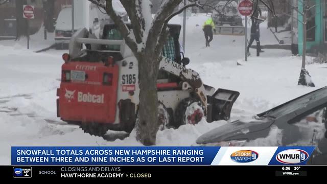
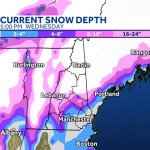
The National Weather Service in Gray, Maine, is calling for widespread snowfall totals between three and six inches across much of New Hampshire. Roads could turn slick quickly after sunset, especially during peak travel hours.
For drivers and school officials, timing will matter.
When Will Snow Start in New Hampshire?
Snow is expected to develop later this afternoon and intensify through the evening, according to the National Weather Service (NWS).
Forecasters say the heaviest snowfall rates are likely during the evening commute window, when temperatures will support steady accumulation on untreated roads.
“Snow will overspread the region late today and continue through tonight,” the NWS Gray office said in its latest forecast discussion. “Travel conditions are expected to deteriorate during the evening hours.”
The system is forecast to taper off early Wednesday morning in most communities, though lingering snow showers may persist in some northern areas.
How Much Snow Will NH Get Tonight?
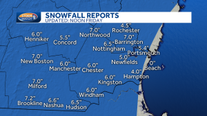
Most of southern and central New Hampshire is projected to receive between 3 and 6 inches of snow.
Localized higher totals are possible in elevated terrain and areas that see steadier snowfall bands.
The NWS snowfall maps indicate:
-
3 to 4 inches in portions of southern New Hampshire
-
4 to 6 inches across central and interior sections
-
Potential for slightly higher amounts in higher elevations
Meteorologists caution that small shifts in the storm track could affect totals by an inch or two in either direction.
Even moderate snowfall during peak travel times can create hazardous conditions quickly.
Impact on the Tuesday Evening Commute
Road conditions are expected to worsen rapidly after sunset.
Snow falling at a steady clip during rush hour could reduce visibility and coat highways before plows can fully respond. Bridges and overpasses are typically the first to ice over.
State transportation officials routinely urge drivers to reduce speed and allow extra stopping distance during active snowfall.
“Even a few inches of accumulation during peak travel can cause significant slowdowns,” one New Hampshire transportation official said during a prior winter briefing. “The safest option is to delay travel if possible.”
Air travel may also experience minor delays, particularly if snowfall rates briefly intensify.
Why February Snowstorms Still Matter in New England
February is historically one of New Hampshire’s snowiest months.
Climatological data show that mid-winter systems frequently deliver moderate snowfall events similar to the one forecast for tonight.
While this storm is not expected to reach blizzard criteria, steady accumulation combined with evening timing increases its impact.
Snowfall totals of 3 to 6 inches may not seem extreme by New England standards, but when paired with commuter traffic, they can disrupt daily routines, school schedules, and business operations.
Timeline of the Snow System
Tuesday Afternoon: Clouds thicken statewide. Snow begins developing from southwest to northeast.
Tuesday Evening: Steadiest snowfall occurs during the commute. Accumulation begins on roadways.
Overnight: Snow continues at a moderate pace across much of the state.
Early Wednesday Morning: Snow tapers off in southern areas; lingering snow showers possible north.
By late Wednesday morning, most of the organized snowfall should be winding down.
Official Forecast and Safety Guidance
The National Weather Service advises residents to monitor updated forecasts and road reports.
“Plan on slippery road conditions,” the NWS Gray office stated in its advisory messaging. “Slow down and use caution while traveling.”
Emergency management officials often remind residents to keep winter safety supplies in vehicles, including blankets, flashlights, and phone chargers.
Municipal crews are expected to treat and plow primary routes overnight.
Public Reaction Across New Hampshire
Residents across the state have been tracking snowfall maps and forecast updates throughout the day.
On social media, many commuters expressed concern about driving conditions during rush hour, while others noted that mid-February snow is typical for the region.
School administrators are also closely monitoring the timing of overnight snowfall in case it affects Wednesday morning schedules.
Local businesses and municipal offices have not announced widespread closures as of Tuesday afternoon, but that could change depending on final totals.
What Happens After This Storm?
Forecasters say this system will move out by Wednesday.
Long-range outlooks suggest continued winter patterns across New England, meaning additional snow chances remain possible before the month ends.
Temperatures are expected to remain seasonably cold, allowing snow to stick around rather than melt quickly.
Residents are encouraged to stay updated with official forecasts, particularly if travel is planned late Tuesday or early Wednesday.
New Hampshire Snowstorm Summary Table
| Event | Winter Snowstorm |
|---|---|
| Location | New Hampshire (statewide impacts) |
| Date | Feb. 10–11 |
| Who Is Affected | Commuters, schools, local businesses, air travelers |
| Expected Snowfall | 3–6 inches in most areas |
| Current Status | Snow developing Tuesday afternoon; heaviest during evening |
| What Readers Should Know | Slippery roads likely during evening commute; snow tapers early Wednesday |
Frequently Asked Questions
How many inches of snow will New Hampshire get tonight?
The National Weather Service forecasts between 3 and 6 inches across much of the state.
When will the snow start in NH?
Snow is expected to begin later Tuesday afternoon and intensify during the evening commute.
Will roads be dangerous tonight?
Yes. Slippery and snow-covered roads are likely during peak travel hours Tuesday evening.
When will the snow stop?
Most areas should see snow taper off early Wednesday morning.
Could snowfall totals change?
Yes. Minor shifts in storm track could increase or decrease totals by an inch or two.
Are school delays possible Wednesday?
School officials typically wait for final overnight totals before making decisions. Updates are expected early Wednesday if needed.
What to Watch Next
Snow will continue through tonight before gradually winding down Wednesday morning.
Travel conditions are expected to improve later in the day as plows clear primary roads. Residents should monitor National Weather Service updates for any changes in snowfall projections or advisories.
Winter is far from over in New Hampshire, and additional systems remain possible in the coming weeks.


Leave a Comment