After one of the warmest and driest starts to winter in recent memory, a dramatic shift is heading toward California.
Forecasters say a powerful Pacific storm system next week could bring widespread rain, flooding concerns and several feet of snow to the Sierra Nevada.
The system may offer long-awaited relief to a record-low Western snowpack. But the same storm could also trigger flash flooding, debris flows and travel disruptions across parts of the state.
Here’s what is expected, why it matters, and what residents should prepare for in the days ahead.
KEY FACTS AT A GLANCE
| Event | Major Pacific storm bringing flood risk and heavy Sierra snow |
|---|---|
| Location | California, Sierra Nevada, parts of the West |
| Date | Expected next week |
| Who Is Affected | California residents, mountain communities, travelers, water managers |
| Current Status | Storm system developing over the Pacific |
| What Readers Should Know | Flooding possible in lower elevations; feet of snow likely in the Sierra |
RECORD WARMTH AND LOW SNOWPACK ACROSS THE WEST
The 2025–2026 winter season has been unusually warm across much of the western United States.
Several states reported below-average precipitation through early winter. Snowpack levels in parts of California and the broader West have fallen well below seasonal norms, raising concerns about water supply heading into spring.
Snowpack acts as a natural reservoir. It melts gradually, feeding rivers and reservoirs that millions depend on for drinking water, agriculture and hydropower.
When snow is scarce, the consequences can stretch into summer.
That’s why next week’s storm is drawing attention from meteorologists and water officials alike.
MAJOR PACIFIC STORM TAKES AIM AT CALIFORNIA
Forecast models show a strong Pacific system organizing offshore before pushing into California.
Meteorologists say the setup resembles an atmospheric river event — a long, concentrated band of moisture that can deliver intense rainfall over a short period.
“This is a significant shift from the dry pattern we’ve been in,” said a meteorologist with the National Weather Service in Sacramento. “We’re looking at widespread precipitation, heavy at times, especially along the coast and in the foothills.”
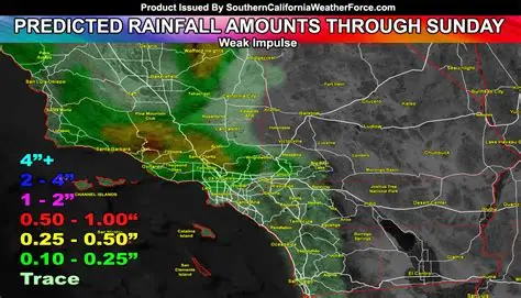
Rainfall totals could climb quickly in lower elevations. In burn scar areas, where vegetation has not fully recovered from past wildfires, the risk of debris flows increases during heavy rain.
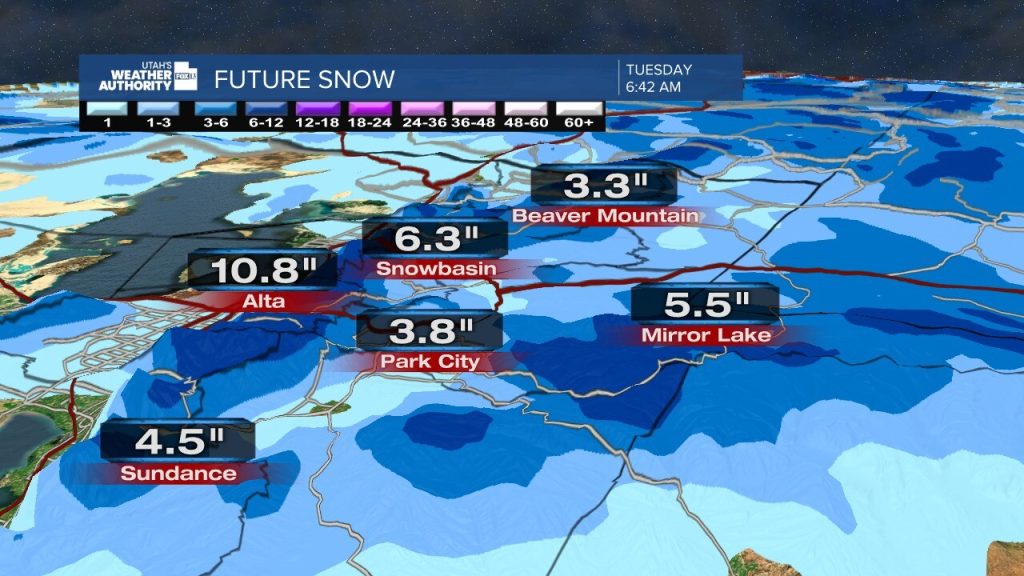
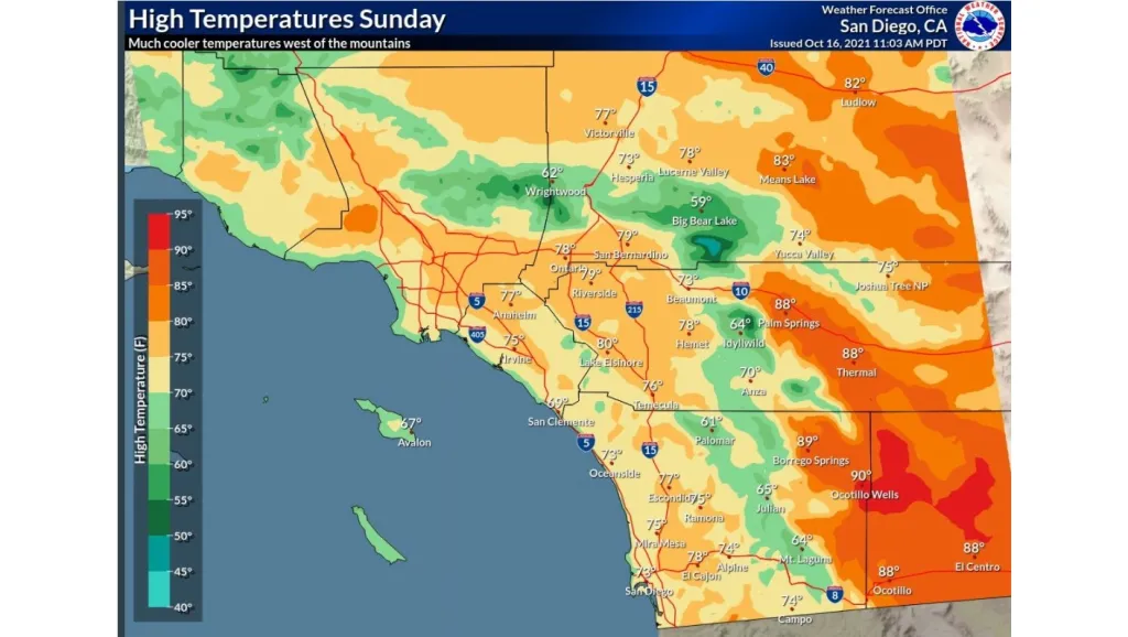
In the Sierra Nevada, colder air at higher elevations will allow snow levels to drop.
“Several feet of snow are possible at the highest elevations,” the meteorologist said. “Travel over mountain passes could become very difficult.”

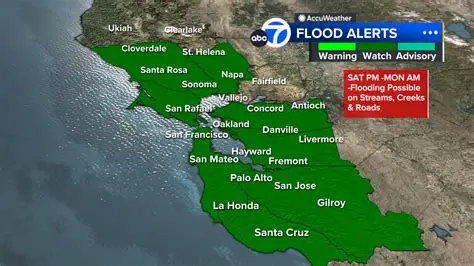
FLOOD THREAT IN LOWER ELEVATIONS
While the Sierra braces for snow, valleys and coastal regions face a different threat.
Periods of heavy rain may overwhelm storm drains and small creeks. Urban flooding is possible in areas with poor drainage.
Flash flooding cannot be ruled out if rainfall rates intensify.
Officials are also monitoring rivers that could rise quickly if rain falls on already saturated ground.
Emergency management agencies typically coordinate sandbag distribution and monitor vulnerable communities during these events. Residents in flood-prone areas are often urged to clear drains and prepare for potential evacuation advisories if conditions worsen.
SIERRA SNOW COULD HELP DROUGHT CONDITIONS
Despite the flood risk, water experts say a strong snowstorm in the Sierra could provide meaningful relief.
California’s water system relies heavily on mountain snowpack, which stores water through winter and releases it gradually in spring.
“This kind of storm can make a big difference, especially if we see sustained snowfall at higher elevations,” said a spokesperson for the California Department of Water Resources. “The key will be how much falls as snow versus rain.”
If snow levels remain high, more precipitation could fall as rain, limiting long-term water storage benefits.
Still, even partial improvement would be welcome after weeks of record warmth and minimal storms.
TIMELINE: WHAT TO EXPECT NEXT WEEK
Early Week:
Clouds increase as the Pacific system approaches the West Coast. Rain may begin along the northern coast.
Midweek:
The storm intensifies as it moves inland. Heavy rain spreads across central and northern California. Snow begins accumulating in the Sierra Nevada.
Late Week:
Peak impacts possible. Flooding concerns grow in lower elevations. Mountain travel disruptions likely as snow totals climb.
Forecast details may shift as the storm approaches, but meteorologists say confidence is increasing in a high-impact event.
TRAVEL AND INFRASTRUCTURE IMPACTS
Drivers traveling through Sierra passes such as Donner Summit may encounter chain controls or temporary closures if snowfall rates increase.
Air travel disruptions are also possible at major airports if heavy rain or wind reduces visibility.
Power outages cannot be ruled out, particularly in areas where strong winds accompany the system.
Utility companies typically stage crews ahead of significant storms to respond quickly to outages.
PUBLIC RESPONSE AND PREPARATIONS
Across California, residents are closely watching updated forecasts.
Some communities have already begun preparing sandbags and checking drainage systems in anticipation of heavy rainfall.
Outdoor recreation plans in the mountains may also be affected.
Local officials often advise residents to avoid driving through flooded roadways and to monitor official weather alerts throughout the event.
WHY THIS STORM MATTERS
This storm represents more than a temporary weather shift.
After weeks of record warmth and historically low precipitation, the West is at a critical point in its winter season. The coming system could either help rebalance water supplies or create new hazards — or both.
The outcome depends on rainfall intensity, snow levels and storm duration.
Weather systems of this scale often carry mixed impacts.
WHAT HAPPENS NEXT
Forecasters will continue refining snowfall and rainfall projections over the coming days.
Flood watches or winter storm warnings may be issued if confidence increases in specific impacts.
Residents are encouraged to monitor updates from the National Weather Service and local emergency management agencies as the storm develops.
FAQ: CALIFORNIA FLOOD THREAT AND SIERRA SNOW
When will the storm hit California?
Current forecasts show impacts beginning early next week, with peak conditions possible mid-to-late week.
How much snow could the Sierra receive?
Higher elevations may see several feet of snow, depending on storm strength and snow levels.
Is flooding likely?
Flooding is possible in lower elevations, especially during periods of heavy rainfall.
Will this help California’s drought?
Significant mountain snowfall could improve snowpack levels, which support water supply later in the year.
Could roads close in the Sierra?
Yes. Heavy snow may lead to chain controls or temporary highway closures.
What is an atmospheric river?
It is a narrow band of moisture in the atmosphere that can deliver intense rainfall when it makes landfall.
Should residents prepare now?
Officials typically advise staying informed, clearing drains and preparing emergency supplies if living in flood-prone areas.
CONCLUSION
A powerful Pacific storm is set to reshape California’s winter outlook next week.
The system could bring both flood concerns and desperately needed Sierra snowfall. The balance between rain and snow will determine how much relief the West sees — and how severe the short-term impacts become.
Updated forecasts and advisories are expected as the storm draws closer. Residents should watch for official alerts and plan accordingly.


Leave a Comment