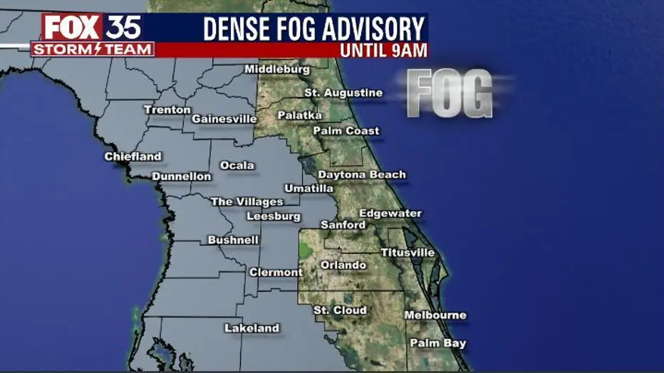
Drivers across parts of Central Florida woke up to limited visibility Thursday morning.
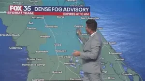
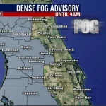
A Dense Fog Advisory was issued for several inland and low-lying areas, warning that visibility could drop to a quarter mile or less in spots before conditions improve.
The advisory comes as temperatures are expected to climb into the mid and upper 70s later in the day, continuing a warming trend across the region.
Forecasters say rain chances will increase heading into the weekend, signaling a shift in the weather pattern for communities along the Interstate 4 corridor and surrounding counties.
Dense Fog Advisory in Effect Across Central Florida
The National Weather Service issued a Dense Fog Advisory early Thursday for parts of Central Florida, including areas around Orlando and neighboring counties.
Dense fog advisories are typically issued when visibility drops to a quarter mile or less, creating hazardous driving conditions during peak commute hours.
“Visibility may be significantly reduced this morning,” the agency said in a public statement. “Motorists should slow down, use low-beam headlights and allow extra travel time.”
The fog developed overnight under calm winds and lingering surface moisture, a common setup during Florida’s late winter pattern.
Why Fog Is Forming in Central Florida
Meteorologists say clear overnight skies combined with light winds allowed temperatures to cool just enough for moisture near the ground to condense.
This type of radiation fog frequently forms in Central Florida during the early morning hours, especially near lakes, wetlands and open fields.
The fog is expected to gradually lift after sunrise as temperatures rise and mixing increases in the lower atmosphere.
By mid-morning, most areas should see improved visibility.
Temperatures Rising Into the Upper 70s
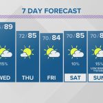
Despite the foggy start, Thursday’s afternoon will feel noticeably warmer.
High temperatures are forecast to reach the mid to upper 70s across much of Central Florida, including metropolitan areas like Orlando and surrounding communities.
The warmer air mass settling over the region marks a return to above-average February temperatures.
“It’s a quick turnaround from foggy and cool to warm and sunny,” a meteorologist with the National Weather Service office in Melbourne said during a morning briefing.
The sunshine and warmth are expected to persist into Friday before rain chances begin to increase.
Timeline: From Foggy Morning to Weekend Rain
Forecasters outline the following progression:
-
Early Thursday Morning: Dense fog advisory in effect; reduced visibility.
-
Late Morning: Fog dissipates; sunshine increases.
-
Thursday Afternoon: Highs reach mid to upper 70s.
-
Friday: Continued warmth with increasing cloud cover.
-
Weekend: Higher rain chances develop across the region.
Rain is not expected to be widespread or severe at this time, but scattered showers could impact outdoor activities.
Weekend Rain Chances Around the I-4 Corridor
Meteorologists are monitoring a developing weather system that could bring scattered showers to parts of Central Florida by the weekend.
Communities along the Interstate 4 corridor — often referred to locally as the “I-4 corridor” — may see periodic rain depending on how the system evolves.
While rainfall totals are not yet finalized, the shift toward wetter conditions could mark the end of the brief sunny stretch.
“Rain chances increase into the weekend as a disturbance approaches from the west,” the National Weather Service noted in its extended forecast discussion.
Residents planning outdoor events should monitor updated forecasts as timing and coverage become clearer.
Public Reaction and Travel Impact
Morning commuters reported patchy visibility along highways and local roads during the advisory period.
Fog can be particularly dense near water bodies and in rural stretches outside city centers.
Local officials remind drivers that fog-related crashes often occur when vehicles are traveling too fast for conditions.
As temperatures rise later in the day, improved road visibility is expected.
The warmer weather has been welcomed by residents after recent cooler mornings, though some have expressed concern about the quick return of rain for the weekend.
What Happens Next
After the fog lifts and Thursday’s warmth settles in, attention turns to the approaching rain system.
Cloud cover is expected to increase Friday, followed by scattered showers over the weekend.
Forecasters will continue evaluating whether rainfall will be brief and isolated or more widespread.
Temperatures are expected to remain relatively mild even as rain chances increase.
Residents are encouraged to check updated advisories, especially during early morning hours when fog conditions are most likely to develop.
Central Florida Weather Summary
| Event | Location | Date | Who Is Affected | Current Status | What Readers Should Know |
|---|---|---|---|---|---|
| Dense Fog Advisory | Parts of Central Florida | Thursday Morning | Commuters, drivers | In effect early morning | Visibility reduced to a quarter mile or less in spots |
| Warmer Afternoon Temperatures | Orlando & surrounding areas | Thursday | Residents, outdoor workers | Forecast | Highs in mid to upper 70s |
| Increasing Rain Chances | Central Florida, I-4 Corridor | Weekend | Residents, event planners | Developing | Scattered showers possible |
FAQ: Central Florida Fog and Rain Outlook
1. What is a Dense Fog Advisory?
It is issued when visibility drops to a quarter mile or less, making travel hazardous.
2. When will the fog clear?
Fog is expected to lift by mid-morning as temperatures rise.
3. How warm will it get Thursday?
High temperatures will reach the mid to upper 70s.
4. Is severe weather expected this weekend?
At this time, forecasts call for scattered showers, not severe storms.
5. Which areas are most affected by the fog?
Inland and low-lying areas, especially near lakes and wetlands.
6. Will temperatures stay warm into the weekend?
Yes, temperatures are expected to remain mild even as rain chances increase.
Conclusion
A Dense Fog Advisory impacted parts of Central Florida Thursday morning, reducing visibility for early commuters before clearing later in the day. Afternoon temperatures are expected to climb into the upper 70s, continuing a warming trend across the region.
Rain chances will increase into the weekend, particularly along the I-4 corridor. Residents should monitor local forecasts for updated timing and coverage as the next system approaches.


Leave a Comment