Southern California is preparing for a stretch of unsettled weather.
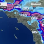
Forecasters say three separate storm systems are lined up over the Pacific and are expected to move across the region over several days.
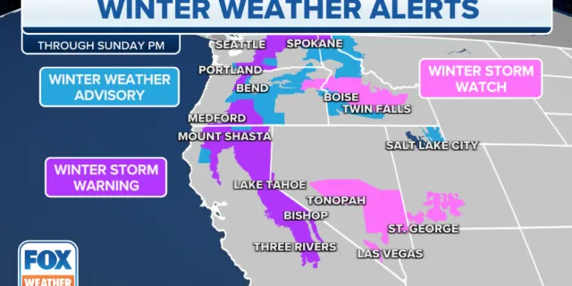
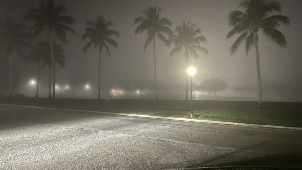
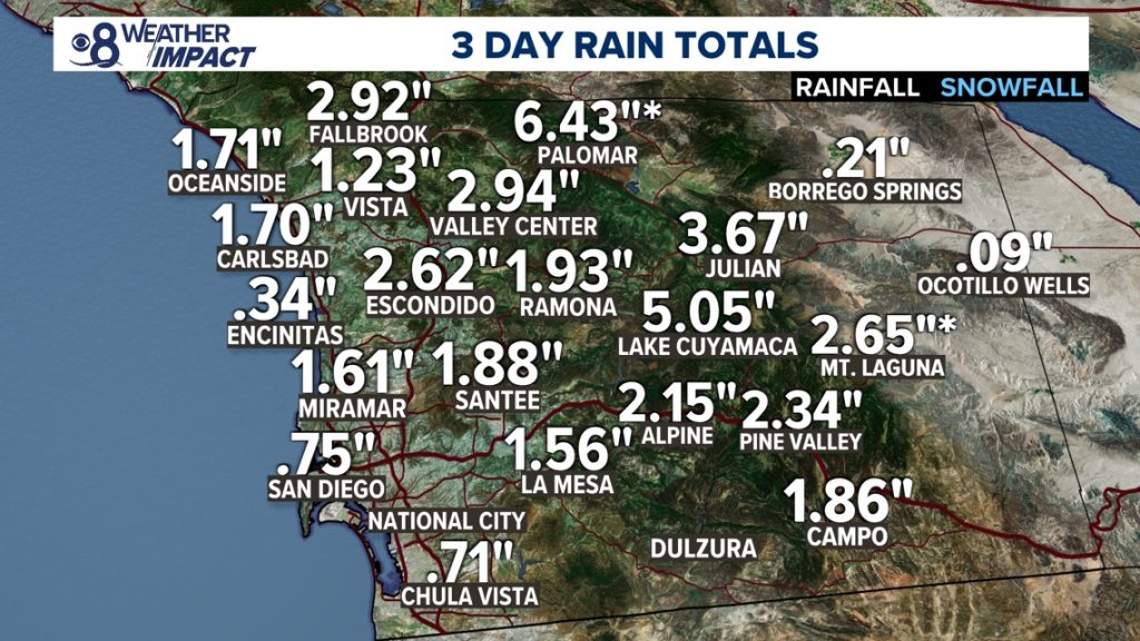
The storms could bring steady rain to coastal and valley communities, heavy snow in the mountains, and periods of gusty winds. Officials are watching burn scar areas closely due to the risk of debris flows.
The developing pattern matters because back-to-back systems can saturate the ground quickly, increasing the risk of flooding, mudslides, and travel disruptions across Los Angeles, Ventura, and San Bernardino counties.
Key Facts at a Glance
| Event | Triple-storm system impacting Southern California |
|---|---|
| Location | Los Angeles County, Ventura County, Orange County, Inland Empire, mountain areas |
| Date | February 2026 (multi-day event) |
| Who Is Affected | Residents, commuters, mountain travelers, burn scar communities |
| Current Status | First storm approaching; additional systems to follow |
| What Readers Should Know | Expect periods of rain, possible flooding, mountain snow, and travel delays |
Storm System Overview: What’s Driving the Pattern
According to the National Weather Service Los Angeles/Oxnard, a series of Pacific low-pressure systems is moving toward the West Coast.
Each storm is expected to arrive in waves rather than as one continuous system.
“This is not a single storm event,” the weather service said in a forecast discussion. “We’re looking at multiple systems moving through over several days, which increases cumulative rainfall totals.”
That cumulative effect is what forecasters are focused on.
While none of the storms individually appears extreme, rainfall totals could add up, especially in foothill and mountain communities.
Storm #1: Light to Moderate Rain Arrives First
The first system is forecast to bring widespread light to moderate rain to coastal and valley areas.
Rain is expected to begin along the Central Coast before spreading south into Los Angeles and Orange counties.
Snow levels may initially remain above major mountain passes but could lower as colder air filters in.
Drivers should anticipate slick roadways during peak commute hours.
Gusty winds are also possible along coastal areas and through mountain passes.
Storm #2: Heavier Rain and Mountain Snow Possible
The second system, projected to arrive shortly after the first exits, may be stronger.
Forecasters say this system could produce steadier rainfall and higher totals in some locations.
“Rainfall rates may increase with the second storm,” the weather service noted. “Urban flooding and ponding on roads will be possible.”
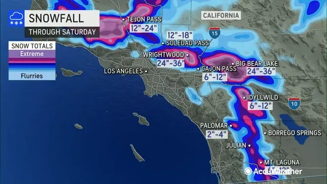
Mountain communities, including areas near Big Bear and Wrightwood, could see accumulating snow.
Caltrans crews are preparing for chain controls if snow levels drop enough to impact major routes.
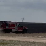
Burn scar areas from recent wildfires are a particular concern.
When rain falls over terrain stripped of vegetation, the risk of debris flows increases.
Local emergency managers are advising residents in vulnerable areas to monitor alerts closely.
Storm #3: Uncertainty in the Forecast
The third system remains several days out, and details could change.
Early forecast models suggest another round of rain, possibly lighter but still impactful given already saturated soils.
Meteorologists caution that even moderate rainfall following two earlier storms could create localized flooding.
“We’ll continue refining totals as we get closer,” the National Weather Service said. “But the extended wet pattern is something people should be aware of.”
Timeline: When the Storms Will Hit
-
Storm 1: Early-to-midweek, bringing widespread rain
-
Storm 2: Late week, potentially stronger with heavier rainfall
-
Storm 3: Following days, additional precipitation possible
Exact timing will vary by county, but the unsettled pattern is expected to last several days.
Periods of dry weather between systems may be brief.
Areas Most at Risk
Urban Flooding in Los Angeles and Orange Counties
Heavy rainfall over short periods can overwhelm storm drains.
Low-lying roadways and underpasses may experience temporary flooding.
Commuters are advised to allow extra travel time.
Mountain Travel Impacts
Snow accumulation could affect travel through the San Bernardino and San Gabriel mountains.
Chain controls are possible if snowfall rates increase.
Burn Scar Debris Flow Risk
Communities near recent wildfire burn scars face elevated risk during moderate to heavy rainfall.
Emergency alerts may be issued if rainfall intensity exceeds debris flow thresholds.
Public Response and Preparedness Efforts
Local agencies are urging residents to clear storm drains and secure outdoor items ahead of gusty winds.
Sandbags are being made available in some counties for residents in flood-prone neighborhoods.
Utility companies are monitoring the potential for isolated power outages due to wind or falling branches.
Emergency officials emphasize preparation rather than alarm.
“This is typical winter weather for Southern California,” one county emergency spokesperson said. “But when storms line up like this, the impacts can build.”
Residents are encouraged to sign up for local emergency alerts and follow official weather updates.
Why This Multi-Storm Pattern Matters
Southern California’s infrastructure is designed to handle winter rain, but repeated systems can strain drainage networks.
Even modest rainfall amounts can cause issues when the ground becomes saturated.
The situation also comes as some reservoirs and waterways are being closely managed after previous wet seasons.
Meteorologists say the current pattern reflects an active Pacific storm track steering systems toward California.
While beneficial for water supply, extended rain events often require careful monitoring for short-term hazards.
What Happens Next
Forecast updates are expected daily as each system approaches.
Rainfall totals, snow levels, and wind speeds may shift depending on storm intensity.
If rainfall projections increase, flood advisories or flash flood watches could be issued.
Travelers planning mountain trips are advised to check road conditions before departing.
Frequently Asked Questions (FAQ)
When will the triple-storm system hit Southern California?
The first storm is expected early in the week, with two additional systems following over several days.
Will Los Angeles see heavy rain?
Periods of moderate to occasionally heavier rain are possible, especially with the second storm.
Is flooding expected?
Urban flooding and ponding on roads are possible, particularly if rainfall rates increase.
Will there be snow in the mountains?
Yes. Mountain areas could see accumulating snow, depending on snow levels.
Are burn scar areas at risk?
Yes. Rainfall over burn scars increases the chance of debris flows.
Should residents prepare for power outages?
Gusty winds and falling branches could cause isolated outages.
How long will the storms last?
The unsettled pattern could last several days, with short breaks between systems.
Conclusion
Southern California is entering a multi-day stretch of wet weather as three Pacific storm systems move across the region.
While none of the storms alone appears extreme, the cumulative impact could lead to localized flooding, mountain snow, and travel disruptions.
Residents are encouraged to monitor official forecasts and prepare for changing conditions throughout the week.
Updates will continue as the systems approach and rainfall totals become clearer.


Leave a Comment