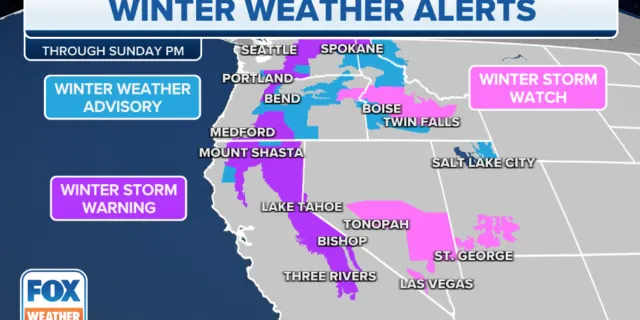
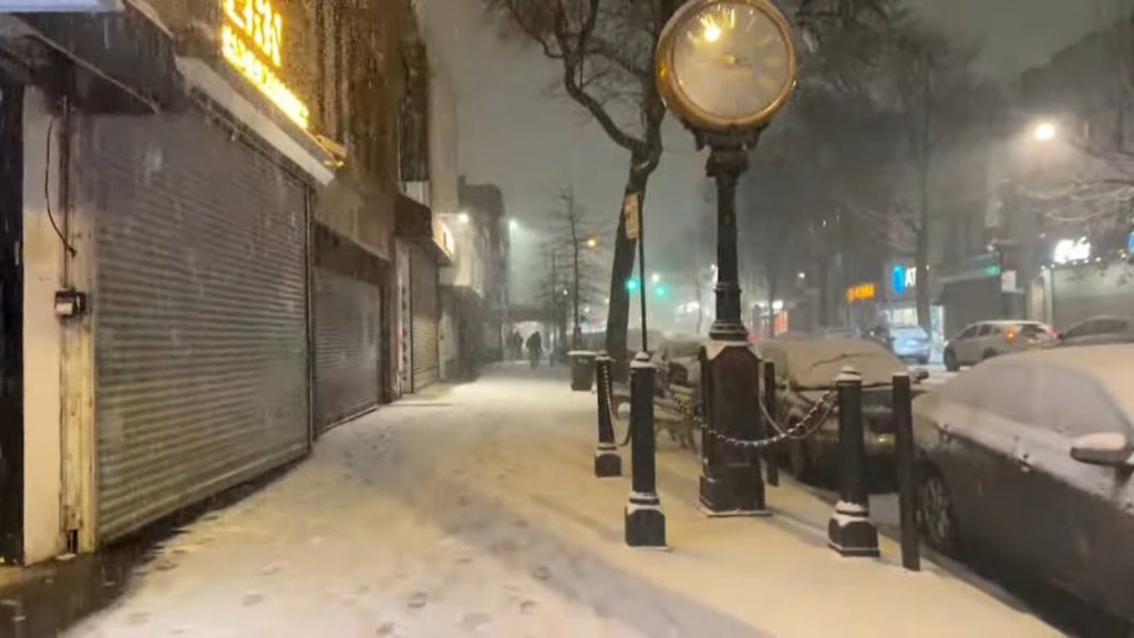
Winter storm warnings are still in effect across five U.S. states, even as the overall number of alerts nationwide has declined.
Forecasters say the remaining warning areas could see up to 24 inches of snow and wind gusts reaching 70 miles per hour. The combination raises the risk of whiteout conditions, power outages and dangerous travel.
The warnings cover parts of the northern and western United States, where colder air and strong storm systems continue to move through. Officials are urging residents to monitor local updates and limit travel during peak conditions.
The situation matters for commuters, freight routes and air travel corridors, especially in regions already dealing with deep snowpack and strong winds this season.
Where Winter Storm Warnings Remain Active
According to the National Weather Service, winter storm warnings remain active in five states as of the latest forecast cycle.
While the total number of warnings nationwide has decreased compared to earlier in the week, meteorologists caution that conditions within the warned areas remain severe.
A winter storm warning is issued when significant snowfall, sleet or ice is expected, creating hazardous conditions. In some cases, blizzard warnings may be issued if strong winds combine with falling or blowing snow to reduce visibility.
“This is a high-impact winter event for the areas still under warning,” an NWS forecaster said in a recent briefing. “Heavy snow and strong winds could make travel extremely dangerous at times.”
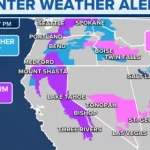
Snow Totals Could Reach 24 Inches
Forecasters project snowfall accumulations ranging from several inches to as much as 24 inches in the hardest-hit zones.
Mountain regions and higher elevations are expected to see the greatest totals. However, lower elevations could also experience significant snowfall, especially where banding develops.
Snowfall rates during the peak of the storm may exceed one inch per hour in some locations. That rate can quickly overwhelm road crews and reduce visibility.
Travel impacts are likely to be widespread in affected counties. Interstates, rural highways and secondary roads may become snow-covered or impassable during heavier bursts.
70 MPH Wind Gusts Raise Blizzard Concerns
In addition to heavy snow, forecasters are tracking wind gusts that could reach 70 mph in exposed areas.
Strong winds can create blowing and drifting snow, even after snowfall tapers off. That can lead to near-zero visibility and sudden whiteout conditions.
The NWS warns that gusty winds may also cause scattered power outages by downing tree limbs and power lines.
“Blowing snow combined with strong winds can reduce visibility to near zero,” the agency said in a public advisory. “If you must travel, keep an emergency kit in your vehicle.”
Blizzard conditions are defined by sustained winds or frequent gusts of at least 35 mph and visibility reduced to a quarter mile or less for at least three hours.
Timeline of the Winter Storm
The current winter storm system developed earlier in the week as cold air settled across parts of the northern United States.
As a low-pressure system intensified, it began producing widespread snow and strong winds across several states.
-
Early Week: Warnings expanded as snowfall intensified.
-
Midweek: Peak snowfall and strongest wind gusts reported in several regions.
-
Late Week: Overall number of warnings decreases, but five states remain under active alerts.
Meteorologists say conditions will gradually improve once the storm system moves east and high pressure builds in behind it.
However, cleanup and recovery may take longer in areas that receive the highest snow totals.
Travel and Infrastructure Impacts
State transportation departments in affected areas have deployed plows and salt trucks, but officials warn that heavy snowfall rates may limit how quickly roads can be cleared.
Air travel could also be affected. Major regional airports in warning areas may experience delays or cancellations depending on visibility and runway conditions.
Utility companies are monitoring wind gust forecasts closely.
Strong winds combined with heavy snow accumulation on power lines can increase the risk of outages. Crews are on standby in several states to respond if needed.
Local emergency management agencies are advising residents to prepare for possible disruptions.
Public Reaction and Safety Guidance
Residents in warning areas have begun sharing images of heavy snowfall and reduced visibility on social media, highlighting rapidly changing road conditions.
Emergency officials continue to emphasize preparation.
“Now is the time to make sure you have supplies at home,” one county emergency management director said during a briefing. “Avoid unnecessary travel while the warning is in effect.”
The NWS advises residents to:
-
Stay off roads during peak snowfall and high winds
-
Keep mobile devices charged
-
Stock up on food, water and medications
-
Check on elderly neighbors
Travelers caught in winter storms are urged to remain in their vehicles if stranded and to conserve fuel while waiting for assistance.
What Happens Next
Forecasters expect the storm system to gradually weaken as it moves away from the warning areas.
Once snowfall ends, attention will shift to clearing roadways and restoring any power outages.
Cold temperatures may linger behind the system, potentially creating icy conditions even after skies clear.
Meteorologists say additional winter weather systems remain possible in the coming weeks, though no new widespread warnings have been issued beyond the current five states.
Residents are encouraged to monitor local forecasts and advisories for updated information.
Winter Storm Warning Summary
| Event | Location | Date | Who Is Affected | Current Status | What Readers Should Know |
|---|---|---|---|---|---|
| Winter Storm Warning | 5 U.S. States | Ongoing | Residents, commuters, travelers | Active | Up to 24 inches of snow possible |
| High Wind Gusts | Warning Areas | Ongoing | Drivers, utility customers | Active | Gusts up to 70 mph may cause blowing snow and outages |
| Travel Impacts | Major highways & local roads | During storm | Motorists, freight routes | Hazardous | Whiteout conditions possible |
| Power Outage Risk | Select regions | During high winds | Homes and businesses | Elevated risk | Strong gusts may down tree limbs and power lines |
FAQ: Winter Storm Warnings Explained
1. What does a winter storm warning mean?
It means significant snow, sleet or ice is expected, creating dangerous travel conditions.
2. How much snow is expected?
Some areas could receive up to 24 inches, especially at higher elevations.
3. How strong will the winds be?
Wind gusts may reach up to 70 mph in exposed areas.
4. Could this become a blizzard?
Blizzard conditions are possible if strong winds combine with heavy snow and reduce visibility.
5. Should people avoid travel?
Officials recommend limiting travel during peak storm conditions.
6. Are power outages likely?
Strong winds and heavy snow may increase the risk of scattered outages.
Conclusion
Winter storm warnings remain in effect across five states as heavy snow and powerful wind gusts continue to impact parts of the country. Although the total number of alerts has decreased nationwide, conditions within the warned areas remain hazardous.
Residents should monitor local updates, follow safety guidance and prepare for travel disruptions until the storm system fully exits the region.


Leave a Comment