It’s a cold start, but it won’t stay that way for long.
After overnight lows dip into the low to mid-20s, temperatures are expected to rebound Friday, bringing a milder end to the week. Clear to mostly clear skies should greet residents at daybreak before sunshine takes over.
The shift comes as a developing weather system begins organizing to the west, setting the stage for rain in the coming days. For commuters and anyone heading out early, patchy fog and frost may create slick spots before the warmer afternoon settles in.
The changing pattern signals a brief taste of early spring before the next round of wet weather arrives.
Clear Skies and Cold Lows Early Friday
Forecasters say skies will remain fair to mostly clear overnight, allowing temperatures to fall sharply.
Morning lows are expected to drop into the low to mid-20s across much of the region. Under calm winds and clear skies, frost formation is likely in several areas.
Patchy fog may also develop in low-lying spots before sunrise.
According to the National Weather Service, cold mornings combined with residual ground moisture can increase the likelihood of frost on exposed surfaces.
“Drivers should watch for isolated slick spots early in the morning,” the agency noted in its latest forecast update.
Friday Forecast: Milder Temperatures and Sunshine
Despite the frosty start, Friday is shaping up to be relatively mild for February standards.
Once the sun rises and temperatures climb, skies are expected to become mainly sunny. Afternoon readings will recover quickly, offering a noticeable contrast to the early morning chill.
Meteorologists describe the pattern as typical of late-winter transitions, where cold overnight lows are followed by steady daytime warming under clear skies.
“It will feel pleasant for February,” one forecaster said in a regional briefing. “The sunshine will make a big difference compared to the morning cold.”
The warmer afternoon may encourage outdoor activity, especially after several days of colder weather.
Why Temperatures Are Rebounding
The milder finish to the week is tied to shifting upper-level winds that are allowing warmer air to move in.
As high pressure settles temporarily over the region, skies clear and sunshine becomes more dominant during the day. That setup promotes efficient warming in the afternoon.
However, this pattern is not expected to last.
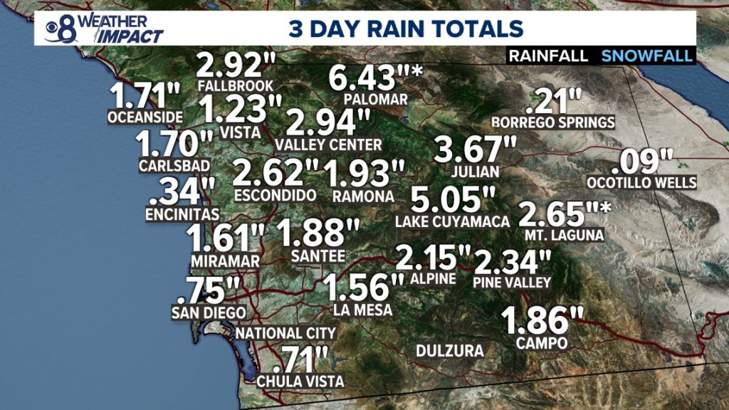
A developing system approaching from the west is forecast to increase cloud cover and bring rain chances in the days ahead.
Rain System Approaching: What to Expect
While Friday will remain dry, forecasters are monitoring the next round of precipitation moving toward the area.
The approaching system is expected to introduce increasing clouds, followed by rain chances beyond Friday.
The timing and intensity of rainfall may vary depending on how quickly the system advances. At this stage, meteorologists emphasize the transition from dry, sunny conditions to a wetter pattern.
Rain following a freeze-thaw cycle can also impact road surfaces, particularly in shaded areas.
Residents are advised to stay updated as the forecast evolves.
Seasonal Context: February Weather Swings
Sharp morning freezes followed by sunny afternoons are not unusual in February.
This time of year often brings temperature swings as cold air masses retreat and milder air begins to push northward. Clear skies overnight allow heat to escape quickly, resulting in colder lows.
Once daylight returns, sunshine can rapidly warm the surface, especially when winds remain light.
These shifts sometimes give the impression of an early spring preview before colder or wetter conditions return.
Public Reaction and Community Impact
Residents waking up to mid-20s temperatures may notice frost on vehicles and lawns.
School buses, early commuters and morning delivery drivers could encounter patchy fog in isolated areas.
By afternoon, however, the sunshine and milder air are expected to improve travel and outdoor conditions.
Some residents have welcomed the brief stretch of sunny weather after recent cold spells.
“It’s nice to see the sun again,” one local resident said Thursday evening. “Even if it starts cold, a sunny afternoon makes a difference.”
What Happens Next
Forecast models indicate that rain will move in after the brief sunny stretch, signaling a return to unsettled weather.
Cloud cover is expected to increase ahead of the next system. Depending on the speed of the incoming front, rain could develop as early as late weekend or early next week.
Temperatures are projected to remain above the morning freeze levels once the warmer air mass settles in more consistently.
Meteorologists will continue refining rainfall totals and timing as new data becomes available.
Weather Summary Table
| Event | Location | Date | Who Is Affected | Current Status | What Readers Should Know |
|---|---|---|---|---|---|
| Overnight Freeze | Regional Area | Early Friday | Morning commuters, homeowners | Expected | Lows in low to mid-20s; frost possible |
| Patchy Fog | Low-lying areas | Friday Morning | Drivers | Possible | Reduced visibility before sunrise |
| Sunny, Milder Afternoon | Regional Area | Friday | Outdoor workers, residents | Forecast | Pleasant February conditions |
| Rain Approaching | Regional Area | Upcoming Days | All residents | Developing | Clouds increase; rain chances ahead |
FAQ: Upcoming Weather Changes
1. How cold will it get overnight?
Temperatures are expected to fall into the low to mid-20s by early Friday morning.
2. Will there be frost?
Yes. Frost is likely in many areas due to clear skies and cold temperatures.
3. Is fog expected?
Patchy fog may develop before sunrise, especially in low-lying spots.
4. Will Friday be warmer?
Yes. Sunshine will help temperatures rebound to milder levels during the afternoon.
5. When will rain arrive?
Rain is expected after Friday as a new system moves into the region.
6. Should drivers take precautions?
Drivers should watch for frost and possible slick patches early Friday morning.
Conclusion
A clear and cold start to Friday will give way to sunny skies and milder temperatures, offering a brief break from recent chill. Morning frost and patchy fog may affect early travel, but conditions improve quickly through the afternoon.
Attention now turns to an approaching system that is expected to bring rain in the coming days. Residents should monitor updated forecasts for timing and potential impacts.


Leave a Comment