
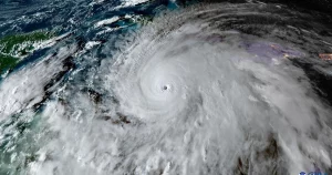
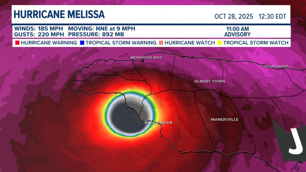
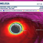
Hurricane Melissa has reached wind speeds that tie the strongest ever recorded in the Atlantic Basin.
The powerful storm intensified rapidly over open waters, reaching peak sustained winds that match the standing Atlantic record, according to meteorologists monitoring the system. The development places Melissa among the most intense hurricanes ever observed in the region.
The milestone is significant not just for record books but for coastal communities tracking the storm’s path. Extreme wind speeds often signal the potential for catastrophic damage, storm surge, and widespread power outages.
Here’s what is known about Hurricane Melissa, how it reached historic intensity, and what comes next.
Hurricane Melissa Wind Speeds Match Atlantic Record
Forecasters confirmed that Hurricane Melissa’s maximum sustained winds tied the current record for the strongest winds ever measured in the Atlantic Basin.
The Atlantic Basin includes the North Atlantic Ocean, the Caribbean Sea, and the Gulf of Mexico — areas routinely monitored during hurricane season.
Meteorologists said Melissa underwent a period of rapid intensification, a phenomenon in which a storm’s wind speeds increase dramatically in a short period of time.
“This is a textbook example of rapid intensification over very warm waters,” said Dr. Michael Brennan, director of the National Hurricane Center, in a briefing. “When environmental conditions line up like this, storms can strengthen faster than many expect.”
The record-tying wind speeds place Melissa in rare company among historic Atlantic hurricanes.
Background: Atlantic Hurricane Wind Records
The strongest hurricanes in the Atlantic Basin are measured by maximum sustained winds over a one-minute period.
Only a handful of storms in modern records have reached the top wind speed threshold now matched by Melissa.
These storms typically form over exceptionally warm ocean waters and encounter low wind shear — conditions that allow the storm structure to remain intact and intensify.
Climate scientist Dr. Philip Klotzbach of Colorado State University noted, “While record-tying storms are rare, we’ve seen an increase in rapid intensification events in recent decades. It’s something researchers continue to study closely.”
The connection between ocean temperatures and hurricane strength has become a growing area of scientific focus.
Timeline of Hurricane Melissa’s Intensification
Hurricane Melissa began as a tropical disturbance over the Atlantic before gradually organizing into a named storm.
Within days, the system strengthened into a hurricane.
Then conditions changed quickly.
Warm sea surface temperatures and minimal atmospheric disruption allowed the storm to intensify sharply. Meteorologists reported a significant jump in sustained wind speeds within a 24-hour period — enough to push Melissa to record-tying intensity.
Satellite imagery showed a well-defined eye and symmetrical structure, signs often associated with the strongest hurricanes.
Forecasters continued round-the-clock monitoring as the storm maintained peak strength.
Where Hurricane Melissa Is Located Now
At the time of the latest advisory, Hurricane Melissa remained over open Atlantic waters.
Its projected path will determine whether it poses a direct threat to land.
Emergency management officials are urging residents in potentially affected regions to monitor official updates closely.
“Even small shifts in track can have big implications for coastal communities,” Brennan said. “Preparation should never wait for absolute certainty.”
Potential Impacts of Record-Level Hurricane Winds
Wind speeds at this level are capable of catastrophic structural damage.
Roofs can be torn off buildings. Power grids may fail across large regions. Trees and debris can become airborne hazards.
Storm surge, often the deadliest component of hurricanes, becomes more severe as wind speeds increase. Surge heights depend on coastline shape and timing but can flood communities far inland.
Heavy rainfall also raises concerns about flash flooding and river overflow.
The full impact depends on whether Melissa maintains strength and makes landfall.
Public Reaction and Preparedness Efforts
News of Hurricane Melissa tying the Atlantic wind record quickly spread across social media and weather platforms.
Some residents expressed alarm. Others focused on preparation.
State and local emergency management agencies have begun reviewing evacuation plans and staging resources where needed.
The Federal Emergency Management Agency has emphasized readiness during active hurricane seasons.
“Preparedness saves lives,” FEMA Administrator Deanne Criswell said in a recent hurricane season briefing unrelated to Melissa. “Communities that act early are better positioned when storms approach.”
Retailers in coastal regions often see spikes in demand for water, batteries, and generators when storms reach historic strength.
Key Facts About Hurricane Melissa
| Event | Location | Date | Who Is Affected | Current Status | What Readers Should Know |
|---|---|---|---|---|---|
| Hurricane Melissa reaches record wind speeds | Atlantic Basin | 2026 | Coastal communities in projected path | Active storm | Tied strongest Atlantic wind record |
| Rapid intensification phase | Open Atlantic waters | 2026 | Emergency management agencies | Monitoring | Intensified sharply within 24 hours |
| Forecast tracking and advisories | National Hurricane Center | Ongoing | Residents in potential impact zones | Active updates | Track could shift |
What Happens Next for Hurricane Melissa?
Forecasters will continue issuing regular advisories tracking Melissa’s intensity and path.
Storms at peak intensity can weaken if they encounter cooler waters or higher wind shear. However, they can also maintain strength longer than expected under favorable conditions.
Emergency officials stress that residents should rely on official sources such as the National Hurricane Center and local authorities for guidance.
Evacuation orders, if issued, will depend on projected landfall timing and surge risk.
The next 48 hours are expected to provide clearer insight into Melissa’s trajectory.
Frequently Asked Questions (FAQ)
What record did Hurricane Melissa tie?
Hurricane Melissa tied the record for strongest sustained winds ever recorded in the Atlantic Basin.
What is rapid intensification?
Rapid intensification occurs when a hurricane’s wind speeds increase dramatically in a short period, typically within 24 hours.
Is Hurricane Melissa expected to make landfall?
Forecast models are still tracking its path. Officials are monitoring for potential landfall risks.
Why are Atlantic wind records significant?
They indicate extremely powerful storms capable of widespread damage and dangerous storm surge.
How can residents prepare?
Follow official advisories, review evacuation plans, and gather emergency supplies if in a potential impact area.
Does warmer ocean water affect hurricanes?
Warmer sea surface temperatures can provide energy that helps storms intensify.
Where can updates be found?
Updates are available through the National Hurricane Center and local emergency management agencies.
Conclusion
Hurricane Melissa has entered the record books, tying the strongest sustained winds ever recorded in the Atlantic Basin.
Whether it ultimately impacts land remains the critical question.
For now, forecasters are closely tracking its path and intensity. Coastal residents should monitor official advisories and be prepared to act if conditions change.
The coming days will determine whether Melissa remains a historic weather event at sea or becomes a major landfalling storm.


Leave a Comment