
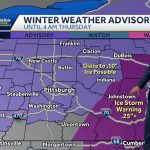
A wintry mix is expected to impact parts of central Ohio on Monday, particularly south of Columbus, before temperatures rise and rain takes over for much of the week.
Forecasters say areas along and south of the I-70 corridor could see snow, sleet or light freezing rain early in the day. In Columbus proper, precipitation is more likely to fall as rain after a brief mix.
The shift in temperatures could limit widespread snow accumulation. Still, even light ice may create slick roads during the morning commute.
Here’s what residents in Columbus and surrounding communities should expect this week — and why Monday’s conditions could matter more than they appear.
Columbus Weather Forecast: Cold Start, Mixed Precipitation Monday
Monday Morning: Snow and Sleet Possible South of Columbus
Temperatures across central Ohio began the week near or below freezing.
As moisture moves into the region Monday morning, colder air near the surface may allow snow or sleet to develop, especially in counties south of Franklin County.
The National Weather Service office in Wilmington, which serves much of central Ohio, has indicated that surface temperatures will be marginal. That means a small change could determine whether precipitation falls as snow, freezing rain or plain rain.
“Confidence is highest for a brief period of mixed precipitation early,” a meteorologist said in a forecast discussion. “Road conditions could vary significantly over short distances.”
Bridges and untreated roads are typically the first to become slick.
Transition to Rain in Columbus
As the day progresses, temperatures are expected to climb above freezing across much of the Columbus metro area.
That change should cause precipitation to switch to rain by late morning or early afternoon in the city itself.
Southern communities, including parts of Pickaway, Ross and Fairfield counties, may hold onto wintry precipitation slightly longer.
The overall expectation is limited accumulation. However, light icing can create hazardous travel conditions even without significant snow totals.
Why a Wintry Mix Matters More Than Snow
Mixed precipitation events are often harder to manage than straightforward snowstorms.
Snow is visible and easier to treat. Freezing rain can coat surfaces in a thin, nearly invisible layer of ice.
Even a light glaze may cause vehicle accidents, school delays or minor power disruptions if ice forms on tree limbs and power lines.
For commuters heading out early Monday, road conditions could change quickly between neighborhoods.
Local transportation crews typically monitor pavement temperatures closely during these transition events.
Milder Temperatures and Rain Through the Week
After Monday’s system moves through, central Ohio is expected to enter a milder pattern.
Daytime highs are forecast to rise into the 40s and possibly low 50s by midweek.
With warmer air in place, precipitation for the remainder of the week should fall primarily as rain.
“The broader pattern is trending milder,” said a Columbus-based broadcast meteorologist. “We’re not looking at a prolonged winter storm setup — more of an active, wet stretch.”
Several disturbances are expected to move through the Midwest and Ohio Valley, bringing periodic rain chances from Tuesday through Friday.
Timeline of Columbus Weather This Week
-
Sunday Night: Cold temperatures settle in across central Ohio.
-
Monday Morning: Snow, sleet or freezing rain possible south of Columbus.
-
Monday Afternoon: Transition to rain across most of the region.
-
Tuesday–Friday: Milder temperatures with scattered rain showers.
-
Late Week: Highs potentially reach upper 40s to low 50s.
Official Forecast Overview
| Event | Location | Date | Who Is Affected | Current Status | What Readers Should Know |
|---|---|---|---|---|---|
| Wintry Mix (Snow/Sleet/Freezing Rain) | South of Columbus, Central Ohio | Monday Morning | Commuters, schools, businesses | Forecasted | Slick roads possible, especially early |
| Rain Transition | Columbus Metro Area | Monday Afternoon | Drivers, residents | Expected | Precipitation changes to rain as temps rise |
| Milder, Wet Pattern | Central Ohio | Mid to Late Week | Entire region | Developing | Highs in 40s–50s; rain more likely than snow |
Background: Typical Late-Winter Pattern in Ohio
Late winter in Ohio often features temperature swings that create mixed precipitation events.
Cold air lingering near the surface can combine with warmer air aloft, producing sleet or freezing rain.
These transitional systems are common in February and March across the Midwest and Ohio Valley.
Columbus sits in a region where minor shifts in storm track can significantly change precipitation type.
Public Reaction and Preparedness
Some central Ohio residents expressed concern about early commute conditions, particularly in suburban and rural areas south of Columbus.
Local road crews have pre-treated certain routes as a precaution.
School districts are expected to monitor conditions before making any delay decisions.
“We always watch pavement temps closely on days like this,” a Franklin County highway official said. “Even a brief icing event can cause issues.”
What Happens Next?
Forecasters will continue refining temperature and precipitation projections as the system approaches.
If temperatures remain colder longer than expected, the risk of light icing could increase.
If warming occurs sooner, most areas would see mainly rain with minimal winter impact.
The second half of the week appears less threatening from a winter weather standpoint, though multiple rain chances could lead to wet roadways and minor ponding in low-lying areas.
No major snowstorm is currently forecast for the Columbus area.
Frequently Asked Questions
1. Will Columbus get snow on Monday?
Columbus may see a brief wintry mix early Monday, but most precipitation is expected to turn to rain.
2. Where is freezing rain most likely?
Areas south of Columbus have a higher chance of sleet or freezing rain Monday morning.
3. How much snow accumulation is expected?
Accumulation appears limited at this time due to rising temperatures.
4. Will roads be dangerous?
Slick spots are possible early Monday, especially on bridges and untreated roads.
5. When will temperatures warm up?
Temperatures are forecast to climb into the 40s and 50s by midweek.
6. Is a major winter storm coming?
Current forecasts do not indicate a major snowstorm for Columbus this week.
7. Will the rain cause flooding?
Widespread flooding is not expected, but localized ponding could occur during heavier showers.
What Residents Should Watch Next
The most important factor will be Monday morning temperatures.
A difference of just a few degrees could determine whether precipitation falls as freezing rain or rain.
Residents are encouraged to check updated forecasts before traveling and remain alert for possible advisories.
After Monday, attention shifts to a milder, wetter pattern across central Ohio — one that signals winter may be loosening its grip, even if briefly.


Leave a Comment