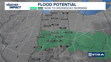
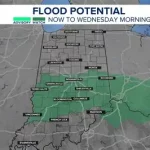
A Flood Watch has been issued for parts of central and southern Indiana as forecasters warn of repeated rounds of heavy rain.
Meteorologists say a so-called “rain train” pattern could bring multiple waves of storms over the same areas, increasing the risk of flash flooding. The alert affects communities across a broad portion of the state.
The warning matters because saturated ground and rising creeks can quickly turn heavy rain into dangerous conditions, especially in low-lying and urban areas.
Residents are being urged to monitor updates and prepare for possible flooding through the duration of the weather event.
Key Facts at a Glance
| Event | Location | Date Issued | Who Is Affected | Current Status | What Residents Should Know |
|---|---|---|---|---|---|
| Flood Watch | Central and Southern Indiana | Latest forecast cycle | Residents, commuters, local businesses | Active | Heavy rain may cause flash flooding |
| “Rain Train” Weather Pattern | Indiana region | Ongoing | Drivers, low-lying communities | Developing | Repeated storms may hit same areas |
| Flash Flood Risk | Urban and rural flood-prone zones | Next 24–48 hours | Homes near creeks, small rivers | Elevated | Avoid flooded roadways |
What Is the “Rain Train” Pattern?
Forecasters use the term “rain train” when storms repeatedly move over the same location, much like train cars on a track.
Instead of a single thunderstorm passing through, multiple systems follow one another along the same path. This can quickly overwhelm drainage systems and small waterways.
The National Weather Service often highlights this setup as a key ingredient for flash flooding, particularly during warmer months when storms are moisture-rich.
“This type of pattern can lead to excessive rainfall totals in a short amount of time,” the agency noted in its forecast discussion. “Areas that see repeated storms could experience rapid water rises.”
Areas Included in the Flood Watch
The Flood Watch covers a wide portion of central and southern Indiana, including several counties near and south of Indianapolis.
Communities along small rivers, creeks, and urban drainage basins are considered particularly vulnerable.
Local emergency management agencies have begun sharing preparedness reminders, encouraging residents to clear storm drains and avoid unnecessary travel during periods of heavy rain.
Officials stress that a Flood Watch does not mean flooding is already occurring. It means conditions are favorable.
Timeline: When the Heaviest Rain Is Expected
Early Phase
Rain chances increase as the first wave of storms moves into the region. Initial rainfall may be moderate but steady.
Peak Rainfall Window
The greatest concern lies during periods when thunderstorms repeatedly track over the same corridor. Forecast models suggest this could occur within the next 24 to 48 hours.
Late Phase
Lingering showers may continue even after the most intense storms move out, slowing water recession in flooded areas.
Meteorologists caution that rainfall totals will vary widely depending on storm placement.
Why Flooding Is a Concern in Indiana
Indiana’s terrain includes river valleys, farmland, and urban zones where water can pool quickly.
When soils are already moist, additional rainfall runs off faster instead of being absorbed. That runoff feeds streams and storm drains.
The Indiana Department of Homeland Security regularly advises residents to follow the “Turn Around, Don’t Drown” principle during flood events.
“Most flood-related deaths occur in vehicles,” the agency states. “Just a few inches of moving water can sweep a car away.”
Official Guidance and Safety Recommendations
The National Weather Service recommends that residents:
-
Monitor weather alerts via NOAA Weather Radio or trusted local outlets
-
Avoid driving through flooded roadways
-
Prepare emergency kits in case of temporary power outages
-
Move valuables from basements if flooding becomes imminent
Local officials also advise checking sump pumps and ensuring gutters and drainage systems are clear.
“Flash flooding can happen quickly, especially at night,” forecasters warned. “Stay alert to changing conditions.”
Public Reaction and Community Preparedness
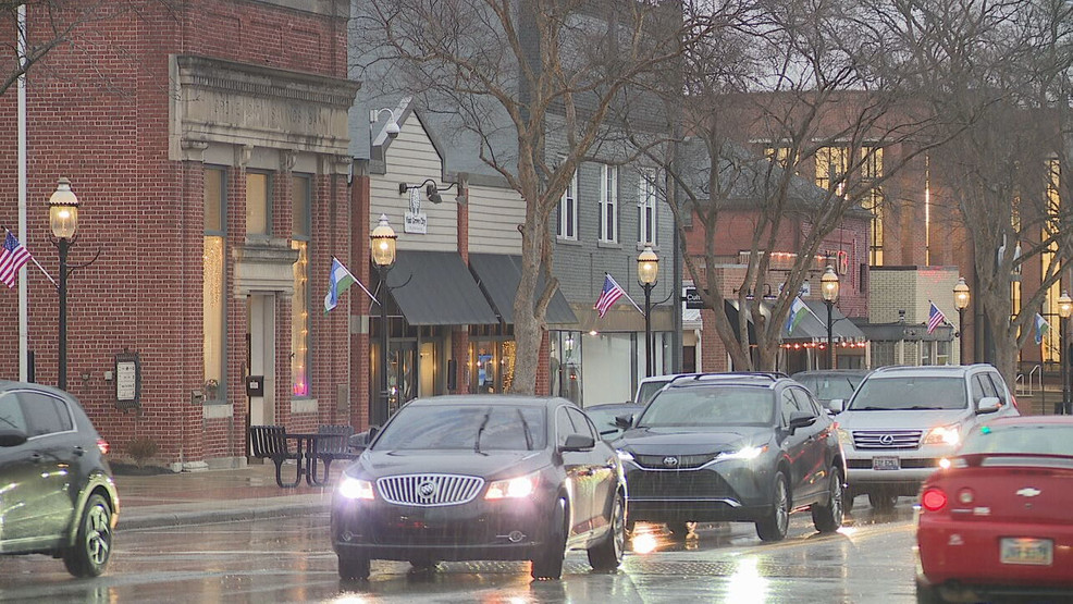
Many Indiana residents took to social media to share photos of darkening skies and early rainfall.
Some expressed concern about past flood events that caused road closures and property damage.
Others said they were preparing by adjusting travel plans and monitoring forecasts more closely.
Local public works departments in several counties reported inspecting culverts and storm drains ahead of heavier rainfall.
The goal is to minimize blockages that could worsen localized flooding.
Broader Weather Pattern Behind the Storms
The “rain train” setup is typically driven by a stalled or slow-moving frontal boundary combined with abundant Gulf moisture.
When upper-level winds steer storms along the same path, rainfall totals can quickly accumulate.
Meteorologists note that summer atmospheric patterns sometimes produce these events when high humidity and unstable air collide.
While not uncommon, the exact placement of heaviest rain bands is difficult to predict more than a day in advance.
That uncertainty is why forecasters emphasize staying updated.
What Happens Next?
Weather models will continue to refine projected rainfall amounts and storm tracks.
If rainfall totals exceed forecast expectations, portions of the Flood Watch area could be upgraded to Flood Warnings, indicating flooding is imminent or already occurring.
River gauges and stream levels will be monitored closely.
The Flood Watch remains in effect through the period specified by local National Weather Service offices, with updates expected as conditions evolve.
Residents are encouraged to check official forecasts regularly.
Frequently Asked Questions
What does a Flood Watch mean in Indiana?
A Flood Watch means conditions are favorable for flooding. It does not mean flooding is already happening.
What is a “rain train” in weather terms?
A “rain train” occurs when multiple storms move over the same area repeatedly, increasing rainfall totals.
How long will the heavy rain last?
Forecasters expect the heaviest rainfall within the next 24 to 48 hours, though timing may vary by location.
Which areas are most at risk?
Low-lying regions, urban areas with poor drainage, and communities near small rivers or creeks face the highest risk.
What should drivers do during a Flood Watch?
Avoid flooded roads and never attempt to drive through standing water.
Could this turn into a Flood Warning?
Yes. If flooding becomes imminent or begins occurring, a Flood Warning may be issued.
The Bottom Line
Central and southern Indiana are under a Flood Watch as repeated storms threaten to bring heavy rainfall in a “rain train” pattern.
While the stock market and global headlines may dominate attention elsewhere, local weather risks can have immediate impacts on travel, property, and daily life.
Residents should stay informed, prepare for possible flash flooding, and monitor official updates as the system unfolds.


Leave a Comment