Snow is building across Central New York, and forecasters say the worst is still ahead.
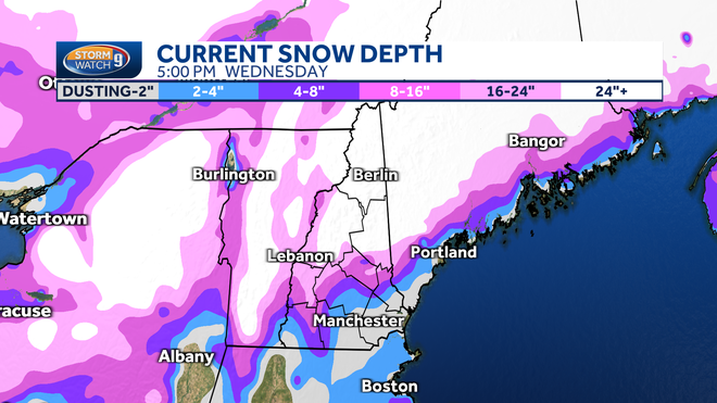
Updated advisories call for up to 7 inches in parts of the region, with the heaviest snow expected Wednesday afternoon and evening — right as many head home from work.
The National Weather Service has expanded and adjusted snow advisories as lake-effect bands organize east of Lake Ontario.
Drivers, schools and local officials are preparing for changing conditions that could quickly reduce visibility and make roads slippery.
KEY FACTS AT A GLANCE
| Event | Updated Winter Weather Advisory – Lake-Effect Snow |
|---|---|
| Location | Central New York (including Onondaga, Oswego, Madison and nearby counties) |
| Date | Wednesday afternoon through late evening |
| Who Is Affected | Residents, commuters, schools, local businesses |
| Current Status | Advisory in effect; snow intensifying |
| What Readers Should Know | Up to 7 inches possible in hardest-hit areas; visibility may drop quickly |
LAKE-EFFECT SNOW RETURNS TO CENTRAL NEW YORK
The current system is driven by lake-effect snow, a familiar winter pattern in upstate New York.
Cold air moving across the relatively warmer waters of Lake Ontario is generating snow bands that can produce narrow but intense bursts of snowfall.
Unlike widespread winter storms, lake-effect systems often lead to sharp differences in totals. One community may see just a couple of inches, while another a few miles away could receive twice that amount.
The National Weather Service updated advisories Wednesday morning to reflect increasing confidence in higher totals in parts of Central New York.
“Lake-effect snow will continue to organize this afternoon,” the NWS office in Binghamton said in a forecast discussion. “The most persistent bands could produce locally higher amounts.”
WHERE THE HEAVIEST SNOW IS EXPECTED
Onondaga, Oswego and Madison counties are among the areas expected to see the highest snowfall totals.
Forecasters say the most concentrated bands are likely to set up during the afternoon and early evening hours.
Snowfall rates could briefly reach one inch per hour in the most intense bands.
That’s enough to quickly coat untreated roads and significantly reduce visibility.
Communities north and east of Syracuse are expected to see some of the steadier accumulations, though shifts in wind direction could alter band placement.
TIMELINE: WHEN CONDITIONS WILL WORSEN
Wednesday Morning:
Light snow develops across parts of Central New York. Accumulations begin but remain modest.
Wednesday Afternoon:
Lake-effect bands intensify. Snow becomes heavier in localized areas. Visibility may drop rapidly during bursts.
Wednesday Evening:
Peak impacts expected during the late afternoon commute into early evening. Roads may become snow-covered in harder-hit zones.
Late Night:
Snow gradually tapers as winds shift and bands weaken.
The timing is a concern for commuters.
“Heavier snow during the evening drive can make travel difficult,” a meteorologist with the National Weather Service said. “Conditions can change quickly under lake-effect bands.”
TRAVEL IMPACTS AND SAFETY CONCERNS
Lake-effect snow is known for producing sudden whiteout conditions.
Drivers may encounter clear pavement one moment and heavy snow the next.
Local transportation departments have pre-treated major roadways, but side streets may become slick as snow accumulates.
Officials are advising drivers to slow down and allow extra time for travel.
School districts across the region are monitoring conditions, though no widespread closures had been announced as of Wednesday morning.
WHY LAKE-EFFECT SNOW CAN BE UNPREDICTABLE
Lake-effect snow depends heavily on wind direction and temperature differences between the lake and the air above it.
Small shifts in wind can move snow bands several miles in either direction.
That means forecast totals can vary significantly over short distances.
Meteorologists use radar and high-resolution models to track band placement in real time, updating advisories as needed.
“It’s very localized,” the NWS meteorologist said. “Some areas will see more than others, even within the same county.”
COMMUNITY RESPONSE
Residents in snow-prone areas are accustomed to lake-effect events, but the timing still poses challenges.
Some businesses reported slower afternoon traffic as people chose to head home earlier than usual.
Local public works departments said crews are prepared to respond as snowfall intensifies.
A spokesperson for a Central New York highway department said plows are on standby.
“We’re ready to adjust as bands move,” the spokesperson said. “Drivers should expect variable conditions.”
WHAT HAPPENS NEXT?
Snow is expected to taper later Wednesday night as winds shift and the lake-effect pattern weakens.
Temperatures will remain cold, meaning any snow that falls is likely to stay on road surfaces overnight.
Forecasters are not currently indicating a major statewide winter storm immediately after this event, though additional light snow showers remain possible in typical lake-effect regions.
Residents are encouraged to monitor updated forecasts throughout the day, especially if traveling during peak snowfall hours.
FAQ: CENTRAL NY SNOW ADVISORY
How much snow is expected in Central New York?
Up to 7 inches in localized areas under persistent lake-effect bands.
When will the heaviest snow fall?
Wednesday afternoon into the evening.
Why are totals different from town to town?
Lake-effect snow bands are narrow and can shift with wind direction.
Will roads be dangerous?
Roads may become snow-covered quickly during heavier bursts.
Are schools closed?
As of Wednesday morning, widespread closures were not reported, but districts are monitoring conditions.
When will the snow end?
Snow should taper later Wednesday night.
What should drivers do?
Reduce speed, increase following distance and watch for sudden changes in visibility.
CONCLUSION
Updated snow advisories across Central New York warn of up to 7 inches in areas under persistent lake-effect bands, with the heaviest snowfall expected Wednesday afternoon and evening.
The timing could affect commuters and evening travel, particularly in Onondaga, Oswego and Madison counties.
Conditions are expected to improve overnight as snow tapers, but residents should continue monitoring local forecasts and road updates as the system evolves.

Leave a Comment