Another round of snow is on the way for parts of the Northeast.
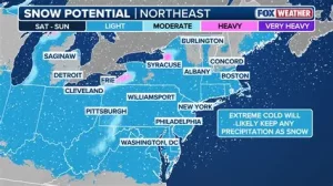
A fast-moving clipper system is expected to bring light but widespread snowfall from western New York to Boston on Tuesday, with accumulation likely during the evening commute along the I-95 corridor.
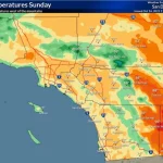
Forecasters say most areas will see between 1 and 3 inches of snow, though higher totals are possible in parts of Upstate New York and higher elevations.
While this will not be a major winter storm, the timing could disrupt travel across several major metro areas.
What Is a Clipper Storm?
A clipper system is a fast-moving, low-pressure weather system that typically forms in western Canada before tracking southeast into the United States.
These storms usually do not carry large amounts of moisture. However, they can produce bursts of snow and reduced visibility as they move quickly across the region.
“Clippers tend to be quick hitters,” said meteorologist Bryan Ramsey with the National Weather Service in Buffalo. “They don’t stick around long, but they can cause problems if they line up with commute times.”
That appears to be the case with Tuesday’s system.
Timeline: When Snow Will Arrive
According to forecast models, snow is expected to develop across western New York Tuesday morning.
Cities including Buffalo and Rochester could see snowfall begin during the early hours, gradually spreading east through the day.
By Tuesday afternoon, snow will expand across central New York and into parts of New England.
The system is expected to reach the I-95 corridor near Boston just in time for the Tuesday evening commute.
That timing could create slick roads and slower travel conditions in one of the region’s busiest traffic periods.
Snowfall Totals and Areas Most Affected
Forecasters project a widespread swath of 1 to 3 inches across much of the Northeast.
Boston is expected to fall within that range.
Higher totals are possible in parts of Upstate New York, particularly in elevated terrain where snowfall rates can increase briefly.
Communities at higher elevations often see slightly enhanced accumulation due to colder surface temperatures.
“This isn’t a blockbuster storm,” Ramsey said. “But even a couple inches can cause delays, especially during rush hour.”
Major highways including I-90, I-87 and I-95 may experience reduced visibility and slick pavement as snow falls.
Impact on Travel and Commuters
Even light snowfall can cause disruptions when it coincides with peak traffic.
The Tuesday evening commute in Boston and surrounding suburbs could see slower travel times as snow accumulates on untreated roads.
Transportation officials typically warn that the first hour of snowfall can be the most hazardous.
Drivers may encounter icy patches, particularly on bridges and overpasses where surfaces cool more quickly.
Air travel may also experience minor delays at regional airports depending on snowfall rates and runway conditions.
Residents are encouraged to monitor local travel advisories and allow extra time for commutes.
Background: A Winter of Repeated Snow Systems
The Northeast has already experienced multiple snow events this season.
While none of the recent systems have produced widespread blizzard conditions, repeated rounds of light to moderate snow have created persistent winter travel challenges.
Clipper systems are common during midwinter months.
They often follow a west-to-east track across the Great Lakes before sweeping through New England.
Their speed limits prolonged impacts, but their frequency can add up over time.
Public Reaction to Another Snow Event
Many residents across western and central New York are accustomed to quick bursts of snow.
Still, timing remains a concern.
“It’s not the amount that worries me,” said Daniel Morris, a commuter in Syracuse. “It’s when it hits. If it starts right before I leave work, that’s when traffic gets messy.”
In the Boston area, commuters echoed similar concerns.
“We’ve dealt with worse,” said Erica Thompson of Cambridge. “But a couple inches at 5 p.m. can turn into a long drive home.”
Local officials have indicated that plow crews are prepared to treat major roadways as needed.
What Happens After the Clipper Passes?
Because clipper systems move quickly, snowfall is expected to taper off late Tuesday night into early Wednesday.
Behind the system, colder air may settle into the region.
Temperatures are forecast to remain near or slightly below seasonal averages.
Forecasters are continuing to monitor additional systems later in the week, though no major storms are currently indicated in short-range projections.
Residents should stay updated as conditions evolve.
Key Facts at a Glance
| Event | Fast-Moving Clipper Snowstorm |
|---|---|
| Location | Western New York to Boston (I-95 corridor) |
| Date | Tuesday (morning through evening commute) |
| Who Is Affected | Commuters, drivers, residents across Northeast metro areas |
| Current Status | Snow developing west to east; 1–3 inches expected |
| What Readers Should Know | Evening commute may be impacted; higher totals possible in Upstate NY and elevated terrain |
FAQ: Northeast Clipper Snowstorm
When will the snow start in western New York?
Snow is expected to begin Tuesday morning in western parts of the state.
How much snow will Boston receive?
Forecasts call for 1 to 3 inches in the Boston area.
Will the Tuesday evening commute be affected?
Yes. Snow reaching the I-95 corridor during evening rush hour could slow travel.
Are higher snowfall totals expected anywhere?
Higher elevations in Upstate New York may see more than 3 inches.
Is this a major winter storm?
No. This is considered a quick-moving clipper system, not a large nor’easter.
When will the snow end?
Snow should taper off late Tuesday night into early Wednesday.
What to Watch Next
The clipper system will move quickly, but its timing may create short-term travel disruptions across the Northeast.
Forecasters will continue monitoring conditions and updating snowfall totals as the system develops.
Commuters should check local forecasts and road advisories before heading out Tuesday afternoon and evening.
Leave a Comment