Winter is making a noticeable return across Utah.
The National Weather Service has issued a series of winter weather advisories for Utah’s mountains, warning that some areas could see their largest snowfall in about a month as a decaying atmospheric river moves through the state.
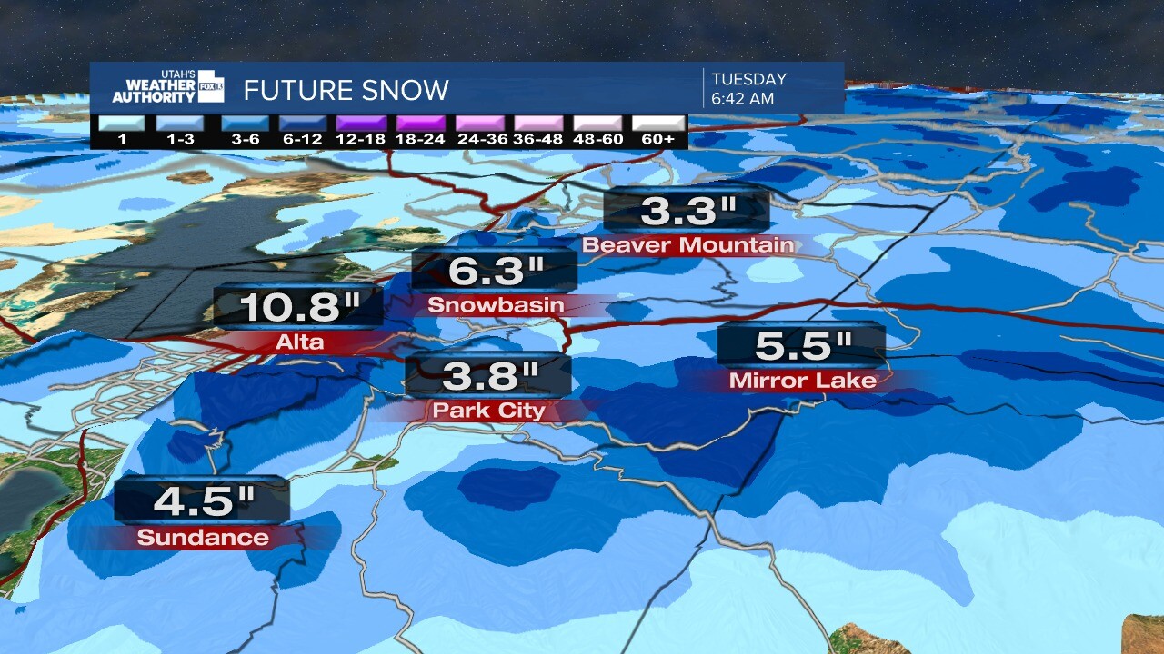
Forecasters say some mountain locations may receive up to a foot of snow or more by the end of Thursday.
The incoming system could also bring wet morning and evening commutes across parts of the state, including the Salt Lake City area.
Atmospheric River to Boost Mountain Snowfall in Utah
Meteorologists say the storm system is tied to a weakening atmospheric river — a long corridor of concentrated moisture in the atmosphere.
While the system is decaying, it still carries enough moisture to produce widespread precipitation across Utah.
“This is the most significant snow we’ve seen in about a month for some of these mountain areas,” said KSL meteorologist Matt Johnson. “It’s not a blockbuster storm, but it’s definitely a healthy shot of moisture.”
The brunt of the precipitation is expected to arrive early Wednesday.
Timeline: When Snow and Rain Will Impact Utah
Light showers may begin Tuesday night in parts of the state.
However, forecasters say the main surge of moisture will move in early Wednesday morning.
Johnson said the system is expected to start with a mix of valley rain and mountain snow in southwest Utah before expanding across much of the rest of the state later in the morning.
That timing could create a wet morning commute, especially along major corridors in northern Utah.
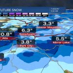
Snow levels are forecast to hover between 6,500 and 7,000 feet elevation.
Communities above that range are more likely to see accumulating snowfall.

Snow Levels and Expected Totals
Mountain regions could receive significant accumulations through Thursday.
Some higher-elevation sites may pick up 12 inches or more before the system exits.
Ski resorts and backcountry areas stand to benefit the most from the incoming snow.
In lower elevations, precipitation is expected to fall primarily as rain, though a rain-snow mix is possible in some areas, especially during heavier bursts.
The mix of rain and snow is expected to continue in waves through Wednesday evening.
Potential Impact on Commutes and Travel
Wet roads are likely Wednesday morning and possibly again Wednesday evening.
Johnson said the pattern could lead to another wet commute Thursday as scattered rain and snow showers linger into the morning and afternoon.
Drivers in mountain passes should prepare for winter driving conditions, including snow-covered roads and reduced visibility.
The Utah Department of Transportation typically advises motorists to check road conditions before traveling through higher elevations during active advisories.
“This system won’t shut things down statewide,” Johnson said. “But if you’re heading into the mountains, you’ll want to be prepared.”
Background: Utah’s Recent Dry Stretch
Utah has experienced relatively modest snowfall totals in recent weeks compared to earlier in the winter season.
While storms have passed through, accumulations have not been widespread or especially heavy in many mountain zones.
That makes this upcoming event notable.
Additional snowfall helps bolster snowpack levels, which are critical for spring runoff and water supply across the state.
Mountain snowpack plays a central role in Utah’s long-term water outlook, particularly as warmer months approach.
Public Reaction to the Incoming Storm
Residents across northern Utah have expressed cautious optimism about the incoming precipitation.
“It’s good to see snow back in the forecast,” said Alex Martinez, who commutes daily from Park City to Salt Lake City. “We need it in the mountains.”
Others are focused on travel conditions.
“I just hope it doesn’t turn into a mess during rush hour,” said Lisa Carter of Draper. “Wet roads are one thing. Snow in the passes is another.”
Skiers and snowboarders have also been monitoring forecasts closely as resorts anticipate fresh snowfall.
National Weather Service Advisory Details
The National Weather Service has issued winter weather advisories for multiple mountain zones across Utah.
Advisories are typically issued when snow or other winter weather conditions could cause travel difficulties.
Officials recommend slowing down, allowing extra time for travel, and keeping emergency supplies in vehicles when driving in snowy areas.
The advisory period extends through Thursday as the system gradually weakens and moves out of the region.
What Happens After Thursday?
Forecasters expect the system to clear out by late Thursday.
Scattered showers may linger into the afternoon before drier conditions return.
Temperatures are expected to remain near seasonal averages.
Longer-range outlooks do not currently show a major follow-up storm immediately after this system, though winter patterns remain active.
Meteorologists will continue monitoring additional moisture streams over the Pacific.
Key Facts at a Glance
| Event | Winter Weather Advisories for Utah Mountains |
|---|---|
| Location | Mountain regions across Utah |
| Date | Tuesday night through Thursday |
| Who Is Affected | Mountain communities, commuters, ski resorts, travelers |
| Current Status | Atmospheric river system bringing snow and rain |
| What Readers Should Know | Up to a foot of snow possible at higher elevations; wet commutes likely |
FAQ: Utah Winter Weather Advisory
How much snow could Utah’s mountains receive?
Some higher-elevation areas could see up to 12 inches or more by Thursday.
When will the heaviest precipitation arrive?
The main surge is expected early Wednesday morning.
What elevation will see snow?
Snow levels are forecast around 6,500 to 7,000 feet and above.
Will Salt Lake City see snow?
Lower elevations are more likely to see rain, though a rain-snow mix is possible at times.
Could travel be impacted?
Yes. Wet roads are likely in valleys, and snowy conditions are expected in mountain passes.
When will the storm clear?
The system is expected to move out by late Thursday.
What to Watch Next
Utah’s mountains are poised for their most significant snowfall in about a month as this atmospheric river system passes through.
Drivers and mountain travelers should monitor forecasts and advisories through Thursday.
Additional updates are expected as the system develops and precipitation totals become clearer.
Leave a Comment